RTT Mapper av Nhà Cái C54
Adds mapping functionality to RealtimeTrains.co.uk
1 brukar1 brukar
Metadata for utvidingar
Skjermbilde
Om denne utvidinga
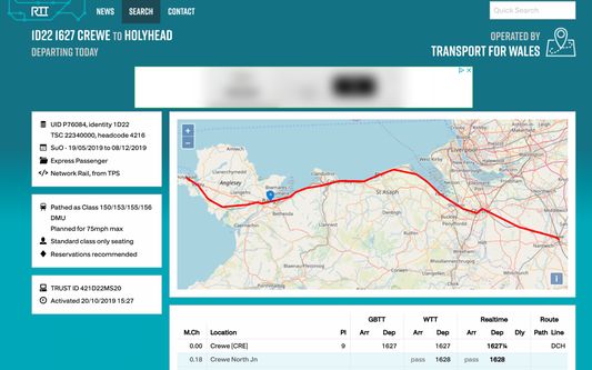
This extension adds OpenStreetMap based functionality to the Realtime Trains website (http://www.realtimetrains.co.uk/).
Features:
- Visualises the route taken by a train on a map
- (Part) cancelled routes are shown in grey
- The last known position of a train is displayed as a marker (if available)
- Route length can be seen by clicking the 'info' button in the bottom right corner of the map
New in version 0.6.0:
- Updated to Manifest v3
- Added display of public calls (circles) and non-public calls (triangles)
- Bit of data cleansing for some obscure routing points
Please note that this extension is not developed by the makers of Realtime Trains and is not affiliated with swlines ltd.
Vurdert 0 av 0 meldarar
Løyve og data
Påkravde løyve:
- Tilgang til dataa dine for www.realtimetrains.co.uk
- Tilgang til dataa dine for realtimetrains.co.uk
Meir informasjon
- Versjon
- 0.6.0.0
- Storleik
- 1,06 MB
- Sist oppdatert
- 7 månader sidan (29. mai 2025)
- Liknande kategoriar
- Lisens
- Alle rettar med atterhald
- Versjonshistorikk
- Legg til i samling